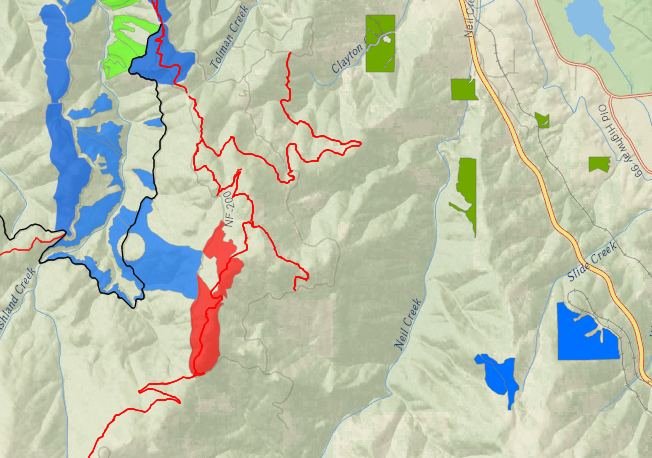
Controlled Burn Planned for Thursday, March 12th: Bull Gap
On Thursday, March 12th a controlled burn is planned on public lands in the Bull Gap Creek area. Ashland Forest Resiliency partners will manage the controlled burn for increased community wildfire safety. The controlled burn is located off the USFS 2080-200 Road high in the watershed. Bull Gap Trail runs through the middle of where crews will be lighting piles. This area is still under some snow, we recommend avoiding Bull Gap and Corp Camp Trails.
Potential Smoke Impact
Smoke will be visible from parts of Ashland, Interstate 5 and Tolman Creek neighborhoods. No roads or trails will be closed, however, there could be some smoke in neighborhoods around the Tolman Creek.
Due to potential smoke, avoid Bull Gap and Corp Camp Trails.
Smoke sensitive people should avoid areas closest to the controlled burn; if you smell smoke, stay indoors and keep windows closed.
Why We Conduct Burns
A recent article in the Ashland Daily Tidings explains more about why we use controlled burns. See 'Fighting Fire with Fire' for details.
More Information
If you live close to a burn location, keep windows closed and if you smell smoke, follow health recommendations on Smokewise Ashland.
Text-based notifications: text the word "WATERSHED" in the message line to 888777 as the recipient. You will get an auto-confirmation text.
Controlled burns are a critical part of creating a safer, more resilient landscape and community in the face of increasing fire risk due to climate change and overgrown forests. Find out more about why we burn.
Online City Services
UTILITIES-Connect/Disconnect, Pay your bill & more�