Ashland Forest Resiliency Project News (View All)
Ashland Loop Road Closure Extended from April 10 through April 14
UPDATE 4/7/2023: This weekend on April 8th and 9th, foot and bike traffic is open for the Ashland Loop Road above Morton Street. Beginning on Monday, from April 10th through Friday, April 14th; the Ashland Loop Road will be closed above Morton for a section of the road a mile below the White Rabbit Trailhead due to an ongoing tree thinning project on private land.
The City of Ashland Oregon is sharing the closure as a courtesy to the landowners who are completing a forest management project on lands that border the Ashland Loop Road. No vehicles will be allowed until road rehabilitation is completed. Delays for the project are due to weather and additional acreage added to the project last week. Thank you for your patience.
UPDATE 3/30/23: During the week, Ashland Loop Road will remain closed to all traffic from April 3 through April 7. Weather dependent, the owners hope to have the road and trails reopened after that.
This information is being supplied by the City as a courtesy to the owners and community. This project is not managed by the Ashland Forest Resiliency Project or City of Ashland.
See Q&A below for more information.
Closure area map:
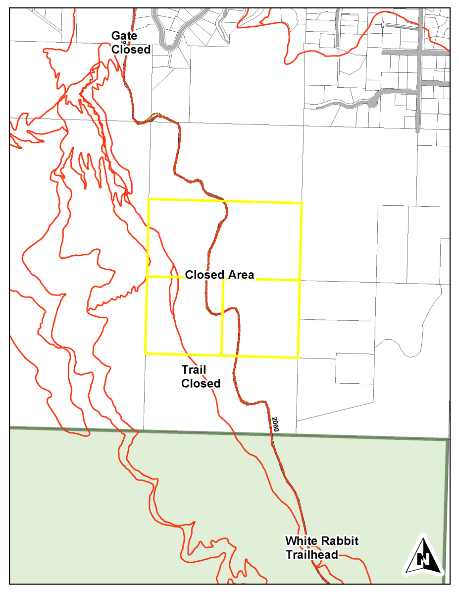
Closed Trails and Roads Include:
Questions and Answers about this project
The City of Ashland Oregon is sharing the closure as a courtesy to the landowners who are completing a forest management project on lands that border the Ashland Loop Road. No vehicles will be allowed until road rehabilitation is completed. Delays for the project are due to weather and additional acreage added to the project last week. Thank you for your patience.
UPDATE 3/30/23: During the week, Ashland Loop Road will remain closed to all traffic from April 3 through April 7. Weather dependent, the owners hope to have the road and trails reopened after that.
This information is being supplied by the City as a courtesy to the owners and community. This project is not managed by the Ashland Forest Resiliency Project or City of Ashland.
See Q&A below for more information.
Closure area map:
Closed Trails and Roads Include:
- Ashland Loop Road above Morton St, 1 mile below the White Rabbit Trailhead
- Alice in Wonderland Trail
- Bandersnatch Trail from Alice in Wonderland to Ashland Loop Road (west side of Bandersnatch is open from Lithia Park side to Alice in Wonderland)
- BTI Trail
- Lower Red Queen via Ashland Loop Road Road and Terrace Street.
- Lithia Loop Road beyond Granite Street Swim Reservoir and Wonder Trail
- Gryphon, Snark, and Waterline Trails
- Jabberwocky via Toothpick Trail only
Questions and Answers about this project
- This project involves four private landowners located outside the City limits, though two of those lots have only minor involvement. The Ashland Loop Road crosses two of the properties on the way to the White Rabbit Trailhead and the Alice in Wonderland trail does as well.
- This work is not part of our ongoing Ashland Forest Resiliency Project. This is not because the work isn’t valuable, but because there wasn’t ample time for proper engagement of the various partners and public to help craft the outcome.
- We are experiencing a die-off in our forests and particularly in Douglas-fir trees (and some pine) that is beyond anything we have experienced in Ashland’s history. Related to the changing climate, recent research from OSU (derived in part from decades of data on City forest lands), describes a “decline spiral”. This is impacting our municipal and Parks lands and is something we need to address further and budget for. Our forests are changing quickly though this isn’t commonly understood, and anticipating this change by cutting quite a number of green trees (in addition to dead and dying) came as a shock to many people.
- The City does have grant funding for wildfire fuels reduction from the Oregon Department of Forestry. A portion is earmarked for private lands around the City and the lots where work is underway are potentially eligible. The grant can fund 75% of the clean-up costs (limbs, branches, small trees and brush) after the logging should the landowners show they did not make a profit by removing trees. The objective of the funds are financial assistance, not profit enhancement. The project will be assessed with the owner(s) after the work is complete to determine their eligibility. The City is not paying for the logging phase of this work, which has been guided by the private owners and is not subject to City oversight or codes.
- Trails and roads will reopen and be brought back to functioning status, or even better than before the work.
- The regulatory oversight for work outside the City limits falls to the Oregon Department of Forestry and the Oregon Forest Practices Act. The owners and contractors have been working with ODF to follow all applicable laws and protections.
- The owners intend to replant more heavily cut areas with more drought tolerant species this spring.
- The area will need to stay closed until work is done to protect public safety.
Online City Services
UTILITIES-Connect/Disconnect,
Pay your bill & more
Pay your bill & more
Connect to
Ashland Fiber Network
Ashland Fiber Network
Request Conservation
Evaluation
Evaluation
Proposals, Bids
& Notifications
& Notifications
Request Building
Inspection
Inspection
Building Permit
Applications
Applications
Apply for Other
Permits & Licenses
Permits & Licenses
Register for
Recreation Programs
Recreation Programs