Ashland Forest Resiliency Project News (View All)
Controlled Burn Continuing on Friday, April 28 through May 1 in Ashland Watershed
UPDATE: Controlled burning went well yesterday with over 60 acres of underburning completed in an area west of Ashland's drinking water source. We recognize the temperatures are warmer on the valley floor. The conditions change at higher elevation where temperatures are cooler and the ground humidity is higher. Controlled burn managers are closely watching burn conditions and managing the prescribed fire for community wildfire risk reduction and, safety is what trained fire managers specialize in for our community's benefit.
Ashland Forest Resiliency is conducting a controlled burn beginning, Thursday, April 27 and as conditions allow, through Monday, May 1. The controlled burn and smoke will be highly visible throughout town and the valley. Please avoid the controlled burn area to reduce your smoke exposure and give fire crews room to work.
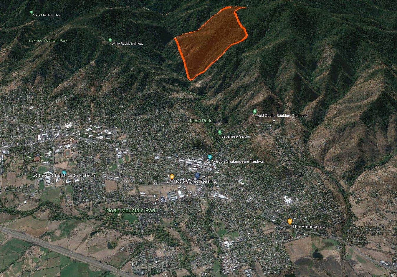
Area in red is the area planned for controlled burning through May 1st
Affected Areas
Several popular trails are located within the controlled burn area including: Wonder Trail and Fell on Knee. Please avoid using trails from the top of Granite Street on west side of the Ashland Loop Road (USFS 2060). Areas directly affected by the burn or smoke include the west side of the Ashland Loop Road (Forest Road 2060) from the swimming reservoir at Granite Street up to Horn Gap. Trails to avoid include Wonder, Fell on Knee, Ricketty, No Candies, and Horn Gap. Trails to the east of Ashland Creek like Jabberwocky and Bandersnatch are better recreation options. Due to traffic, ongoing burn operations and drifting smoke; please avoid the west side of the watershed. See the map above for burn locations.
|
Location |
Areas directly affected by the burn or smoke include the west side of the Ashland Loop Road (Forest Road 2060) from the swimming reservoir at Granite Street up to Horn Gap. Trails to avoid include Wonder, Fell on Knee, Ricketty, No Candies, and Horn Gap. |
|
Expected duration of the controlled burn |
Burn operations will begin on April 27th and as conditions allow, continue through Monday, May 1st. Please be aware that as conditions allow, operations may continue over the weekend on April 29th and 30th. |
|
Smoke Impact |
Several trails will be impacted. Please view the map and avoid the west side trails above the Granite Swim Reservoir. See where smoke is moving on the watershed camera. |
|
Be Smoke Ready |
Smokewise Ashland has resources to stay healthy when smoke is in the air. |
|
Stay Updated |
See project updates on the AFR webpage. |
|
Assistance for Notifications |
For assistance in signing up for notifications, email sara.jones@ashland.or.us. |
Putting Fire to Work for Our Community: Please Excuse our Smoke
Spring burn season is upon us and burning on City of Ashland, Ashland Parks and Recreation Commission, and Rogue River-Siskiyou National Forest lands in and around the city’s municipal watershed is ramping up. Reintroducing the long-absent role of mild fires to reduce the summer wildfire threat is a primary goal on public and private land under the Ashland Forest Resiliency (AFR) Project and the City’s Ashland Forest Plan.
Planned fires are managed by trained and specialized teams. Each burn has goals to minimize smoke impacts while reducing fuels and promoting forest health. Burn plans are currently approved on thousands of acres and fire managers will use proactive fire planning technology, called Potential Operational Delineations, or PODs, to prioritize burn areas, along with conditions as measured on the ground each week.
Reigniting a Legacy of Good Fire
For time immemorial, indigenous tribes like the Shasta and Takelma managed local forests with frequent burns to promote health and well-being of people and forests. European colonization led to the absence of fire for the past 150 years, causing significant changes in the forest. Local research has reaffirmed the key role “good fire” plays in Southern Oregon’s dry forests. Since 2010, AFR partners and the City have worked on over 13,500 acres to remove overly-dense trees and flammable brush, creating opportunities to maintain our forests with safely conducted controlled burns…returning good fire to the landscape.
Prescribed Fire Reduces Smoke Impacts
Studies have shown that although controlled burns can expose people to smoke, that smoke is shorter in duration and typically less intense than summer wildfire smoke. And importantly, by reestablishing proactive burning at a landscape scale, we can limit the destruction caused by wildfires and limit periods of summer smoke inundation. Regardless of the source of smoke, vulnerable people need to protect themselves when smoke is in the air. Please see our Smokewise Ashland program to learn about keeping your air clean and knowing when burns are planned.
We can have a safer and healthier future for our community by supporting this critical work. See www.ashlandwatershed.org for controlled burn information, and www.rogueforestpartners.org, for more information about forests around Ashland and all of Southern Oregon.
Stay Informed During Controlled Burn Season
-
Register for the AFR Project email list
-
Text WATERSHED in the message line to 888777 to get text notifications about burns
-
Visit www.ashlandwatershed.org to learn more about good fire
-
Follow us on Facebook at AFR.Project or on Twitter @ashlandforest
-
See SmokewiseAshland.org and take action to reduce smoke exposure
Online City Services
Pay your bill & more
Ashland Fiber Network
Evaluation
& Notifications
Inspection
Applications
Permits & Licenses
Recreation Programs