Ashland Forest Resiliency Project News (View All)
Controlled Burn Planned for Thursday in the Ashland Watershed
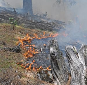 |
Underburn conditions are associated with warmer and drier weather like we've had and is forecasted this week. This burning is a critical piece of our ongoing work to prepare for hotter and drier summers associated with a changing climate.
Additionally, feel free to check out the following link for our online burn map showing location and status of our burn units.
SMRD Burning
Online City Services
UTILITIES-Connect/Disconnect,
Pay your bill & more�
Pay your bill & more�
Connect to
Ashland Fiber Network
Ashland Fiber Network
Request Conservation
Evaluation
Evaluation
Proposals, Bids
& Notifications
& Notifications
Request Building
Inspection
Inspection
Building Permit
Applications
Applications
Apply for Other
Permits & Licenses
Permits & Licenses
Register for
Recreation Programs
Recreation Programs