Ashland Forest Resiliency Project News (View All)
Controlled Burn Planned Today: USFS 2080 Road
A high elevation burn is planned in the Ashland watershed for Tuesday, November 2nd. Rogue River-Siskiyou National Forest (RRSNF) will manage the controlled burn off the USFS 2080 and 2080-200 roads on behalf of the Ashland Forest Resiliency project. Due to high elevation and distance from town, smoke is not expected to impact neighborhoods. Lower Bull Gap and Missing Links Trails will have smoke. Hikers or bikers should avoid these trails today. Please see alternative routes here.
Our Smokewise Ashland site has all the resources you need to stay healthy when smoke is in the air. Also, learn where AFR Partners will conduct burns in 2021-2022 on the controlled burn map.
Please sign up for our burn alerts, particularly for smoke sensitive people who need to take precautions.
To receive non-emergency burning and smoke alerts:
Click here for a video about proactive fire planning to learn how a little smoke from controlled burning is helping make our forests healthier and our community safer in the face of increasingly hot and dry summers.
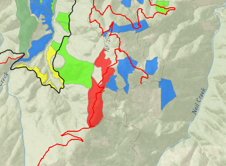
Our Smokewise Ashland site has all the resources you need to stay healthy when smoke is in the air. Also, learn where AFR Partners will conduct burns in 2021-2022 on the controlled burn map.
Please sign up for our burn alerts, particularly for smoke sensitive people who need to take precautions.
To receive non-emergency burning and smoke alerts:
- Text WATERSHED in the message line to 888777 for non-emergency notifications
- Register for the AFR email
- Follow AFR on Facebook
- Or find us on Twitter
- Learn more on our website
Click here for a video about proactive fire planning to learn how a little smoke from controlled burning is helping make our forests healthier and our community safer in the face of increasingly hot and dry summers.
Online City Services
UTILITIES-Connect/Disconnect,
Pay your bill & more�
Pay your bill & more�
Connect to
Ashland Fiber Network
Ashland Fiber Network
Request Conservation
Evaluation
Evaluation
Proposals, Bids
& Notifications
& Notifications
Request Building
Inspection
Inspection
Building Permit
Applications
Applications
Apply for Other
Permits & Licenses
Permits & Licenses
Register for
Recreation Programs
Recreation Programs