Ashland Forest Resiliency Project News (View All)
Two Controlled Burns Beginning at Noon Today, February 16th - Ashland Mine Road and Siskiyou Blvd near upper Tolman Creek Road
The Ashland Forest Resiliency has a two controlled burns planned today:
- One is off Ashland Mine Road, northwest of town.
- A second burn is near the 3000 block of Siskiyou Blvd and upper Tolman Creek Road.
Potential Smoke Impact
- Likelihood: Smoke may impact 3000 block of Siskiyou Blvd and, Ashland Mine Road on Tuesday, February 16th, primarily during evening and overnight hours.
- Affected Activities: We recommend avoiding outdoor activities close to the burn area and in predicted impact areas during evening and overnight hours.
- Precautions: Stay inside, close windows, turn on air purifiers, wear 95 masks as needed, if smoke is present. Find health precautions for smoke on Smokewise Ashland.
- Visible Smoke Likely: Smoke will be visible from parts of southeast Ashland, northwest Ashland and from Interstate 5.
As defined by the Center of Disease Control, persons under 15, adults over 65 and those who have pre-existing conditions including heart and lung disease, asthma and chronic obstructive pulmonary disease (COPD) are most vulnerable to smoke. If you have household members who are at risk, we encourage you to apply.
Please apply in either English or Spanish before Midnight on Sunday, February 21st, 2021. If you have difficulty with the electronic application or have questions, please call (541) 552-2218. See the controlled burn map:
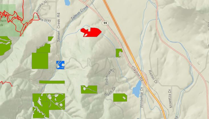
- Areas highlighted in red are active controlled burns
- Those highlighted in yellow were recently burned and being monitored
- Blue areas are planned controlled burns
- Green represents completed burns
- For burn day notifications, text the word "WATERSHED" in the message line to 888777 as the recipient. You will get an auto-confirmation text when you sign-up.
- AFR Facebook
- smokewiseashland.org
- See controlled burn on the watershed camera
- Burn locations can be accessed through an online map
- Download the app: Nixle Phone Application through Everbridge
Online City Services
UTILITIES-Connect/Disconnect,
Pay your bill & more�
Pay your bill & more�
Connect to
Ashland Fiber Network
Ashland Fiber Network
Request Conservation
Evaluation
Evaluation
Proposals, Bids
& Notifications
& Notifications
Request Building
Inspection
Inspection
Building Permit
Applications
Applications
Apply for Other
Permits & Licenses
Permits & Licenses
Register for
Recreation Programs
Recreation Programs