Ashland Forest Resiliency Project News (View All)
Controlled Burning: Ashland Loop Road and No Candies Trail
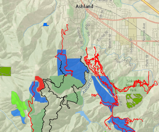
On Tuesday November 30th, Rogue River-Siskiyou National Forest Service is managing a controlled burn on behalf of the Ashland Forest Resiliency. This rare late fall underburn is located along the 2060-400 road close to the No Candies Trail, so please avoid the area due to traffic and smoke. Find alternative trail routes here and how to avoid smoke exposure at the Smokewise Ashland website. Check weather and smoke on the watershed camera.
Potential Smoke Impact: Moderate Risk
- Smoke will be visible from parts of west Ashland and from Interstate 5.
- Smoke impact is expected near the controlled burn along the No Candies Trail and Ashland Loop Road (2060 and 2060-400).
- During the evening hours, smoke could enter upper neighborhoods of West Ashland (Ashland Mine Road to Granite Street) and upper Wagner Creek in Talent.
Click here for a video about proactive fire planning to learn how a little smoke from controlled burning is helping make our forests healthier and our community safer in the face of increasingly hot and dry summers.
Our Smokewise Ashland site has all the resources you need to stay healthy when smoke is in the air. Also, learn where AFR Partners will conduct burns in 2021-2022 on the controlled burn map.
Please sign up for our burn alerts, particularly for smoke sensitive people who need to take precautions.
To receive non-emergency burning and smoke alerts:
Online City Services
UTILITIES-Connect/Disconnect,
Pay your bill & more
Pay your bill & more
Connect to
Ashland Fiber Network
Ashland Fiber Network
Request Conservation
Evaluation
Evaluation
Proposals, Bids
& Notifications
& Notifications
Request Building
Inspection
Inspection
Building Permit
Applications
Applications
Apply for Other
Permits & Licenses
Permits & Licenses
Register for
Recreation Programs
Recreation Programs