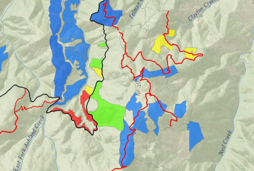
Controlled Burn Planned for Friday the 26th in the Ashland Watershed
On Friday (2/26/21), the AFR Partners plan to do a controlled burn consisting to clear piles in the east side of the Ashland Watershed along the road west of the Four Corners area. No trails or roads will be closed however the 2060 road will have areas with heavy smoke impacts adjacent to unit areas during pile ignition. Thanks for the continued patience as we continue to do the important work of removing these excess fuels from the Ashland watershed.
Smoke will be visible but should not impact any populated areas.
Areas highlighted in red are active controlled burns
Those highlighted in yellow were recently burned and being monitored
Blue areas are planned controlled burns
Green represents completed burns
More Information
For burn day notifications, text the word "WATERSHED" in the message line to 888777 as the recipient. You will get an auto-confirmation text when you sign-up. Download the app: Nixle Phone Application through Everbridge to receive daily messages.