Ashland Forest Resiliency Project News (View All)
Controlled Burn South of Siskiyou Mountain Park on Wednesday, January 13th
On Wednesday, January 13th, the Ashland Forest Resiliency partners are conducting a controlled burn to clear piles south of Siskiyou Mountain Park. In the evening hours, Greenmeadows neighborhood and upper Clay Street will potentially have smoke. Lomakatsi Restoration Project fire crews will be on site to manage the controlled burn.
Potential Smoke Impact
- The controlled burn is located close to hiking trails in Siskiyou Mountain Park, please avoid these if you are sensitive to smoke.
- Greenmeadows and upper Clay street could have smoke in the evening hours.
- Smoke will be visible from parts of east Ashland and from south Interstate 5.
- Follow precautions on Smokewise Ashland.
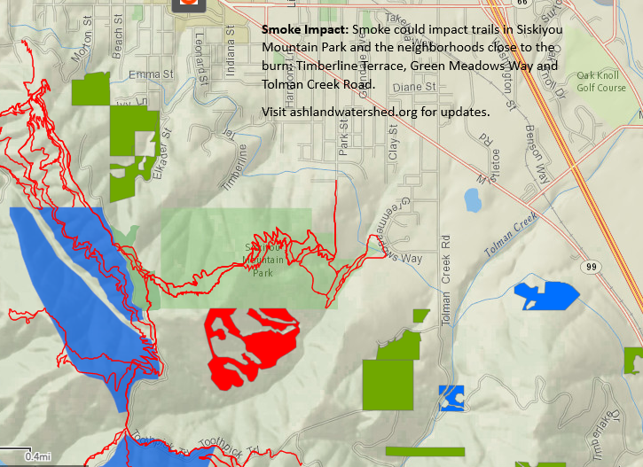
For the controlled burn map; areas highlighted in red are active controlled burns and those highlighted in yellow are being monitored.
More Information
- For non-emergency notifications, text the word "WATERSHED" in the message line to 888777 as the recipient. You will get an auto-confirmation text when you sign-up.
- AFR Facebook
- smokewiseashland.org
- See controlled burn on the watershed camera
- Burn locations can be accessed through an online map
Online City Services
UTILITIES-Connect/Disconnect,
Pay your bill & more�
Pay your bill & more�
Connect to
Ashland Fiber Network
Ashland Fiber Network
Request Conservation
Evaluation
Evaluation
Proposals, Bids
& Notifications
& Notifications
Request Building
Inspection
Inspection
Building Permit
Applications
Applications
Apply for Other
Permits & Licenses
Permits & Licenses
Register for
Recreation Programs
Recreation Programs