Ashland Forest Resiliency Project News (View All)
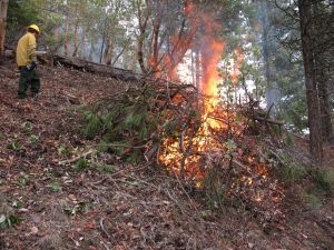
Two Controlled Burns Planned for Wednesday, December 4th
 |
Here's a map of the burn units
Controlled burning is a critical part of creating a safer, more resilient landscape in the face of increasing fire risk due to climate change and overgrown forests. For more information and alerts, see below.
More Information
- ashlandwatershed.org
- Text based notifications: text the word "WATERSHED" in the message line to 888777 as the recipient. You will get an auto confirmation text.
- AFR Facebook
- smokewiseashland.org
People sensitive to smoke should protect themselves should smoke affect the community. Smokewise Ashland has resources to help protect you and your family.
Find out more about why we burn.
AFR is a ten-year stewardship project designed to reduce the risk of severe wildfire in the watershed and to protect water quality, older forests, wildlife, people, property and quality of life.
Online City Services
UTILITIES-Connect/Disconnect,
Pay your bill & more�
Pay your bill & more�
Connect to
Ashland Fiber Network
Ashland Fiber Network
Request Conservation
Evaluation
Evaluation
Proposals, Bids
& Notifications
& Notifications
Request Building
Inspection
Inspection
Building Permit
Applications
Applications
Apply for Other
Permits & Licenses
Permits & Licenses
Register for
Recreation Programs
Recreation Programs